I’ve always loved maps. They reward the longer gaze. Especially in these digitally frenetic times. Whether depicting authentic truths or questionable claims, or one of many shades in between, they tend to provoke expansive thinking about the world. Or they zoom you in on something unexpected and compelling. Their borders inherently are porous to the imagination. And they can be just plain cool to look at — hand me a copy of Oxford’s Atlas of the World and I’ll be entertained for a healthy chunk of time flipping through those oversized pages. No iPhone necessary.
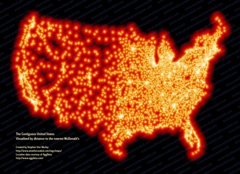
Of course, digital media allow mapmakers and collectors to take things to a next level. The Strange Maps blog is one great place to browse. A recent post featured the work of blogger Stephen Von Worley, who decided to chart America as fast-food dystopia by depicting McDonald’s ubiquity from coast to coast. The nagging question that was his point of departure: What’s the “McFarthest” one can possibly get from a Big Mac? Unsurprisingly, not very far at all, even in the relatively unpopulated West:

According to Von Worley’s calculations (per the summary at Strange Maps):
There are over 13,000 McDonald’s restaurants in the U.S., or about 1 for every 23,000 Americans. But even market penetration this advanced doesn’t mean that McDonald’s is everywhere. Somewhere in South Dakota is the McFarthest Spot, the place in the [continental] U.S. geographically most removed from the nearest McD’s. If you started out from this location, a few miles north of State Highway 20 (which runs latitudinally between Highways 73 in the west and 65 in the east), you’d have to drive 145 miles to get your Big Mac. (If you could fly, however, it’d be only 107 miles).
If you did decide to fly, you’d be contributing to some incredibly congested air traffic, especially if it’s during daylight. See this nifty depiction of 24 hours worth of planes flying the global skies:
Also worth watching is this feat of mapmaking by Senator Al Franken, who from memory composed one of the United States (while taking questions, no less) at the Minnesota State Fair:
Now if he and his comrades could only draw up a health care plan with such facility…
Posted in culture, media Tagged: art, economy, environment, globalization, maps, politics, technology, travel
